
The essentials in two minutes
A cloud tells you two things: where it lives (low, middle or high — that’s the prefix of its name) and how the air that made it behaves. Balls, cauliflowers, pebbles: the air is rising in packets; it is unstable. Sheets or veils: the air has been lifted slowly and in one piece; it is stable. Add “nimbo-” or “-nimbus” and it rains. With these three keys — level, shape, rain — you can already name the ten cloud genera.
For pilots and hikers alike, four clouds matter more than all the others. First, cumulus: its flat base marks the top of the thermals, and its shape measures the day’s energy. If it grows taller faster than it grows wider before midday, a thunderstorm is on its way. Next, altocumulus with turrets (castellanus): seen in the morning, it heralds a stormy afternoon. Then lenticulars, those lenses that stay put despite the wind: it is blowing hard at altitude, and the mountain is making waves and rotors. Finally, the cirrus veil thickening from the west: a frontal system is on its way, and the window will close in a day or two.
The rest is a matter of eye and habit: dating a cloud (is it being born or dying?), spotting the ones the terrain makes, and above all watching the sky change through the morning, because a photo tells you nothing and a film tells you everything.
P.1Three keys to name ten clouds#
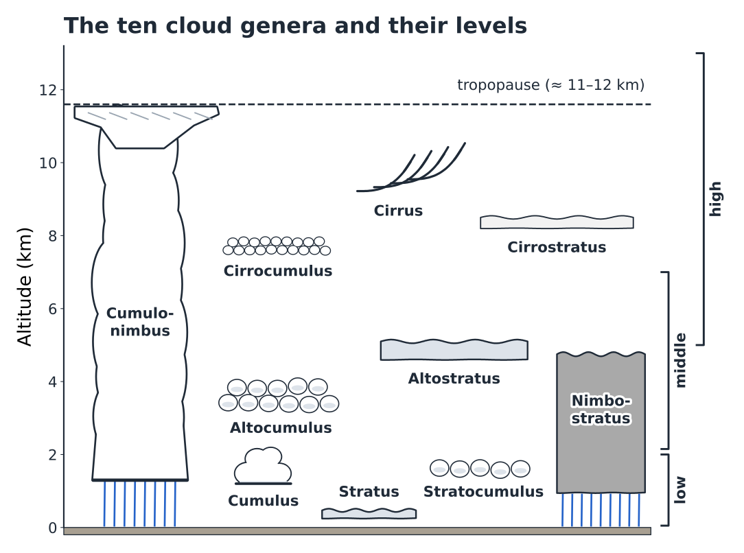
The international cloud classification fits on the back of an envelope. You cross two questions — at what height does the cloud live, and what shape is it? — and add a flag for rain. The result comes down to ten genera, which cover everything you will see above a launch or a pass (Fig. P.1).
First key: the level
The prefix gives the altitude. Cirro-: high level, roughly between 5 and 13 km, where it is so cold (−30 to −60 °C) that the cloud is made of ice crystals — hence its fibrous, silky look, never sharp-edged. Alto-: middle level, between 2 and 7 km, a mix of supercooled droplets and ice. No prefix: low level, below 2 km, water droplets. The limits overlap and come down in winter; they are landmarks, not borders.
A pitfall for mountain-goers: these altitudes are measured above sea level. A “low” stratocumulus at 1,800 m drowns the ridges of the Prealps; a “middle” altocumulus at 3,500 m grazes the summits of the Écrins massif. In the mountains, the low level is often our level.
Second key: the shape
The shape gives away how the air was lifted — and therefore its stability, the central topic of chapter 1. A cumuliform cloud (in heaps, balls or pebbles) is born from packets of air that each rise on their own: the air is unstable, there is convection, and therefore lift and turbulence. A stratiform cloud (in sheets or veils) is born from a whole layer lifted slowly and in one piece, for example over a frontal surface: the air is stable; it slides along without overturning.
Third key: rain
Nimbus is Latin for rain cloud. Only two genera carry this flag: nimbostratus, the great grey sheet of continuous rain, and cumulonimbus, the thunderstorm cloud. The others may let fall a few drops, or trails that evaporate on the way down, but they are not rain-makers.
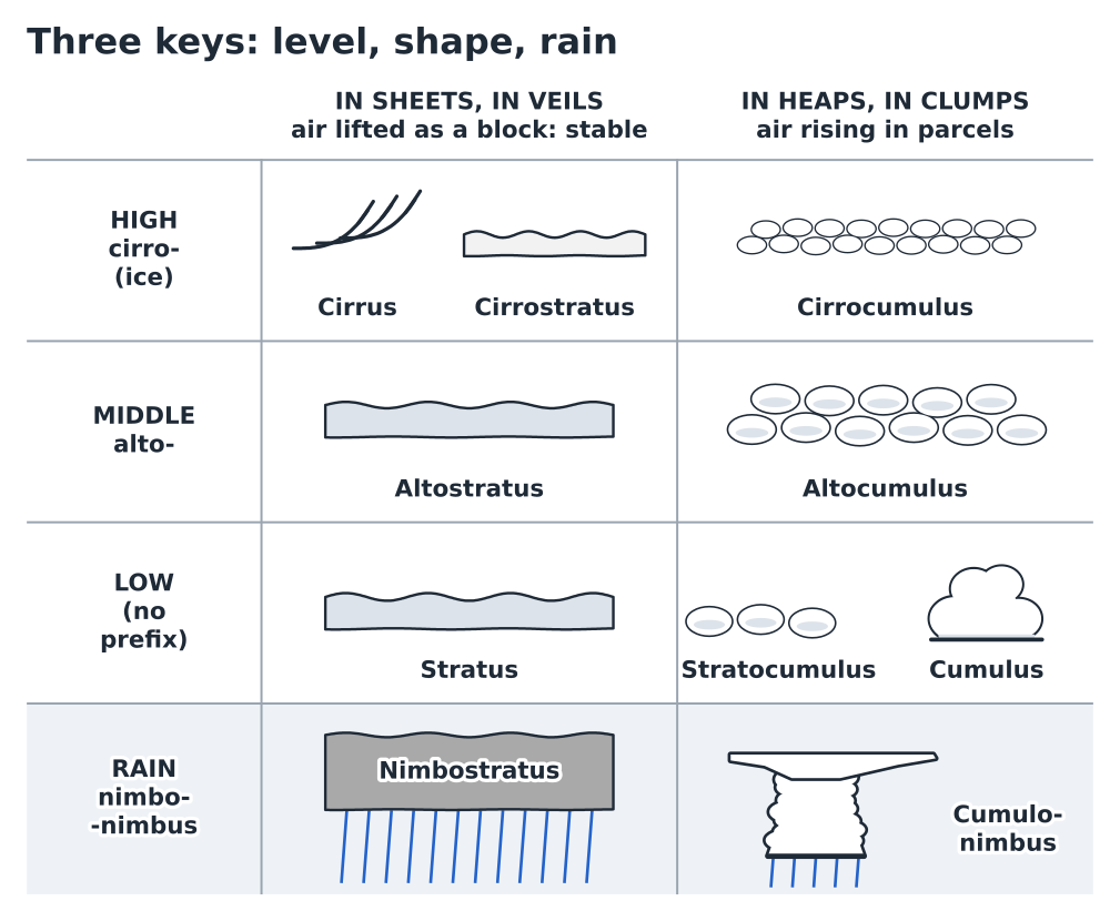
Beyond the genus, meteorologists specify the species (humilis, congestus, castellanus, lenticularis…) and supplementary features (virga, pileus, mamma, arcus…). There is no need to remember them all. This prelude keeps only the names that change a decision.
P.2The high level: the messengers#
Ice clouds never produce rain and hinder neither flying nor hiking. Their interest lies elsewhere: they travel far ahead of frontal systems, carried by the strong winds aloft, and often arrive a day before the bad weather.
Cirrus appears as white filaments, wisps, sometimes curled-up commas (“mares’ tails”). Isolated and motionless in a blue sky, they tell you nothing. If they invade the sky from the west, lengthening and thickening as the hours go by, they are the vanguard of a warm front (chapter 4): the front is expected within 24 to 36 hours, sometimes less, and the rain often comes a few hours ahead of it.
Cirrostratus is a milky veil, so thin that the sun stays sharp and shadows stay distinct. Its distinctive sign is the halo: a ring of light with a radius of about 22° around the sun or moon, drawn by the ice crystals. A halo that appears after a morning of cirrus confirms that the front is approaching.
Cirrocumulus forms tiny white grains, without shadows, arranged in ripples or scales: the “mackerel sky” of the old sayings. It is rare and short-lived; it signals a little instability at very high altitude, with no direct consequence for us.
In flight
A thickening cirrus veil cuts out part of the solar radiation: the ground heats less, thermals weaken and the day can “switch off” earlier than forecast, even without a single low cloud. At launch, a sky turning white from the west is a reason to fly early and not to count on the late afternoon.
P.3The middle level: the warning signs#
Altostratus is a grey or bluish sheet covering the sky. The sun shows through it as if “behind frosted glass”, pale, with no halo, and shadows on the ground disappear. It is the logical sequel to cirrostratus as the warm front approaches: rain is a few hours away. For thermal flying, the day is over before it has begun.
Nimbostratus is altostratus that has thickened until it almost touches the ground: a grey, dark, shapeless mass from which continuous rain (or snow) falls for hours. In the mountains, its base drowns the ridges, often below 1,500 m, and low shreds (fractus) trail through the valleys. No flying and no ridge route that day.
Altocumulus forms patches of grey and white pebbles or rolls, with shaded parts: you can make out each element, clearly bigger than a cirrocumulus grain (at arm’s length, the width of one to three fingers). On its own and flat, it says little. It is one of its species that matters.
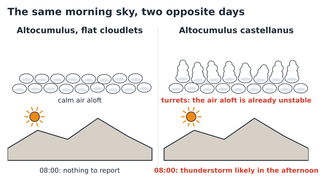
Altocumulus castellanus carries turrets that build on top of the pebbles, like the battlements of a castle (Fig. P.3). Its cousin, altocumulus floccus, looks like frayed tufts of cotton wool, often with trails hanging beneath them. Both say the same thing: the air is already unstable at around 3,000 to 5,000 m, before the sun has even warmed the ground. As soon as the convection rising from below reaches this layer, the cumulus will be able to climb unchecked.
In flight
Castellanus or floccus above launch in the morning: fly early, stay close to the landing fields, and land before the first cumulus start building in earnest — in summer, often as early as 13:00. This is not the day for the big cross-country flight.
Hiker’s reflex
Same sky, same conclusion: set off by headtorch, summit in the morning, ridges and arêtes left behind before midday. Castellanus is the best reason there is to set your alarm an hour earlier.
P.4The low level: stratus and stratocumulus#
Stratus is a uniform grey sheet with a very low base, sometimes right down at ground level: it is fog that no longer touches the ground. It forms in moist, stable air, cooled from below during the night or lifted gently against a slope. At most it gives drizzle. It often fills the valley floors in the early morning, especially after a day of rain, and clears as the sun nibbles it away, often between 09:00 and midday.
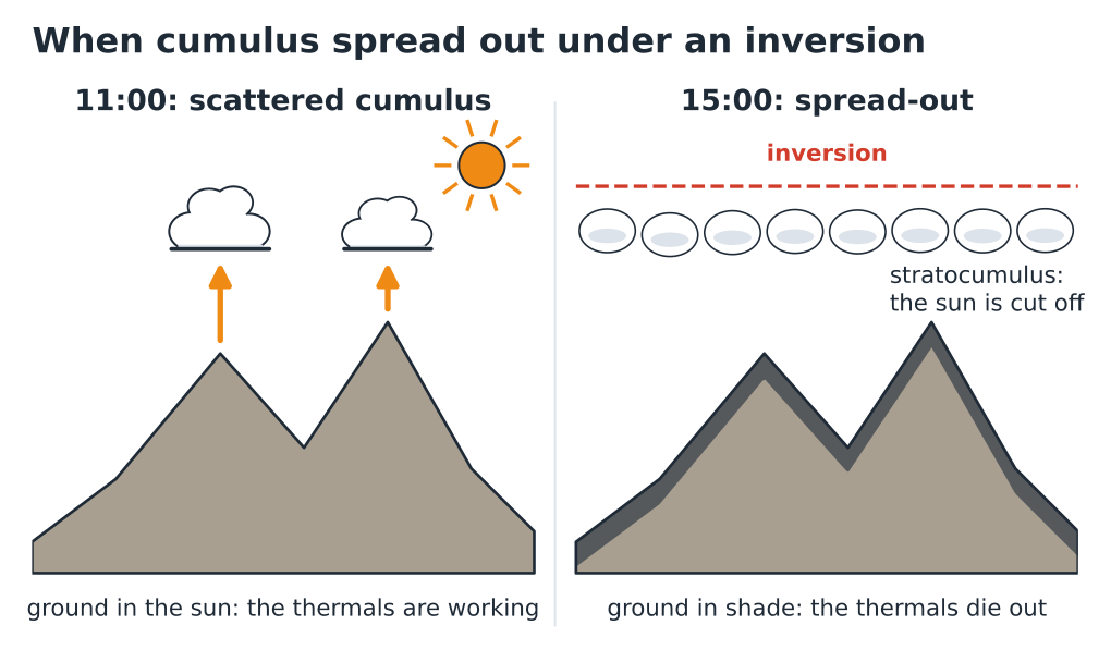
Stratocumulus forms a sheet made of large grey pebbles or rolls welded together, with gaps. It has two origins that matter to us. It can be what is left of a humid night, breaking up into cumulus as the ground warms. Or it can be the reverse: cumulus that, blocked beneath an inversion, spread out against one another until they close the sky (Fig. P.4). The sky then goes, in a few tens of minutes, from “nice cumulus” to “uniform grey”.
In flight
A sky that “closes over” from above is bad news if you are far from the landing field: thermals weaken everywhere at once. Spot the areas still in sunshine and head for them, or head back. Under thick stratocumulus, the air is often calm and the flight turns back into a glide.
P.5Cumulus, our cloud#
Cumulus is the free-flight cloud. Its base is flat because it marks the exact altitude where rising air reaches saturation: the condensation level, which chapter 1 shows you how to calculate to within 100 m. Its building top shows that air is still rising inside it. Every cumulus is the visible part of a thermal.
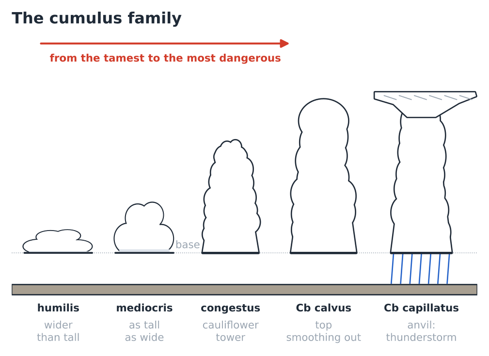
Four stages, from the gentlest to the most dangerous
The species of cumulus measure its vertical development, and therefore the day’s energy (Fig. P.5).
Humilis: flat, wider than it is tall. The convective layer is shallow or capped by a nearby inversion. Thermals are often weak and the ceiling low, but the sky holds no danger.
Mediocris: about as tall as it is wide, with a moderately building top. This is the classic good thermal day.
Congestus: clearly taller than it is wide, a tower with a cauliflower top and very sharp outlines. The lift is strong and deep; showers become possible. A congestus before midday is a signal to take seriously.
Cumulonimbus: the tower reaches the level where water freezes. Its top loses its sharp outlines, becomes smooth (calvus), then fibrous, and spreads out into an anvil of ice (capillatus). This is the thunderstorm, with its gusts, its lightning and its hail.
Dating a cumulus
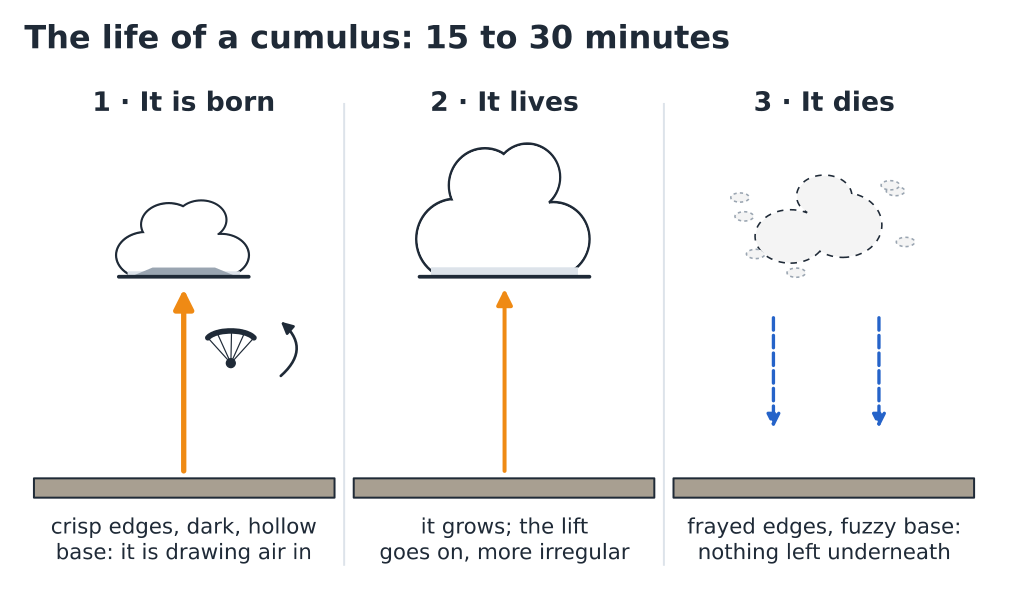
A fair-weather cumulus lives on average a quarter of an hour to half an hour. Being able to tell, from a distance, whether it is being born or dying is worth more than knowing all its Latin names (Fig. P.6).
A cumulus being born has sharp, hard outlines and a dark base, sometimes slightly hollowed upwards: it is being fed, and the rising air is beneath it. One in its prime grows bigger and wider, and its lift goes on, broader and more irregular. One that is dying has frayed edges, a blurred base that fades away, and shreds breaking off: it is no longer being fed, nothing is rising beneath it, and the air that surrounded it sometimes sinks back down.
In flight
Aim for the cloud that is forming, not the one that looks good: by the time you get under a magnificent cumulus, it may have come to the end of its life. The best clues are a brand-new cloud, small wisps appearing and thickening before your eyes, a dark, sharp base. Think about drift too: in a light or moderate wind, the thermal is rarely directly below the cloud, but a little further upwind and lower down on the terrain.
Cloud streets
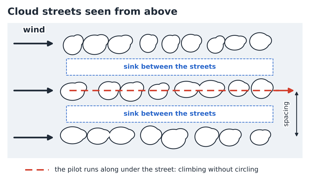
When the wind is fairly strong and constant in direction through the whole depth of the convective layer, the cumulus line up in long streets parallel to the wind (Fig. P.7). Under each street, the lift is almost continuous; between two streets, the air sinks. The spacing between two streets is roughly two to three times the depth of the layer where the thermals form.
Three details that matter
The pileus is a small, smooth, lens-shaped cap sitting just above a building tower. It forms when the tower lifts the layer of air above it so fast that this layer condenses in turn: a sign of very violent lift and of rapid development under way. Virga are trails of rain or snow that hang beneath a cloud and evaporate before reaching the ground. This evaporation cools the air, which becomes heavy and plunges: under virga, you find sink and gusts. Finally, fractus is a ragged shred of cloud, often under the base of a rain cloud or in a damp valley; it signals saturated air very low down.
P.6Cumulonimbus and its signs#
A cumulonimbus is not a big cumulus: it is a machine that reaches up to the tropopause, at around 10 to 12 km in summer, and produces violent updraughts, violent downdraughts, lightning and hail all at once. Chapter 9 sets out its dangers in detail; here, the aim is to recognise it, including by the secondary signs that come with it (Fig. P.8).
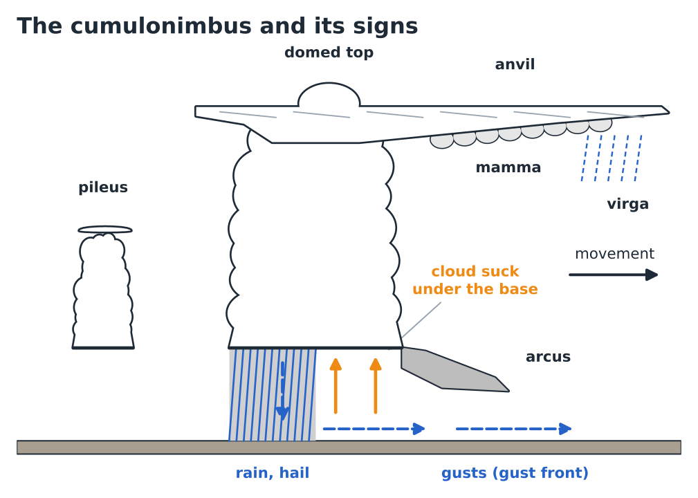
The anvil is the top part, made of ice, flattened against the tropopause and stretched out by the upper wind. It can extend tens of kilometres ahead of the storm. The dome top that pierces it reveals an updraught so strong that it overshoots its equilibrium level. Mamma, rounded pouches hanging beneath the anvil, come with mature storms and strong turbulence. The arcus (shelf cloud) is a dark, horizontal roll ahead of and beneath the base: it marks the gust front, the cold air flowing out of the storm and lifting the warm air ahead of it. When you see it coming, the wind will shift and strengthen within minutes.
In flight
Under a congestus turning into a cumulonimbus, the lift widens and strengthens (5 to 10 m/s, sometimes more) until it exceeds the sink rate of a wing with big ears and on speed bar: this is cloud suck. The only remedy is anticipation: leave the area while the cloud is still “exploding”, not once you are already under its base. And land well ahead of the gust front, which can sweep across a landing field several kilometres from the storm, with a wind that shifts and exceeds 50 to 80 km/h.
Hiker’s reflex
An anvil spreading over your route, a first rumble, a cold wind suddenly getting up: come down from the ridges and summits without waiting for the rain. Lightning can strike more than 10 km from the storm, and the first drops often arrive after the first flash.
P.7Clouds made by the terrain#
A mountain forces the air to rise. If the air is moist enough, it condenses on the windward slope or above the summit, and evaporates as it comes down the other side. These orographic clouds stay attached to the terrain while the wind blows through them: they seem motionless, yet they are constantly renewing themselves. That is their signature (Fig. P.9).
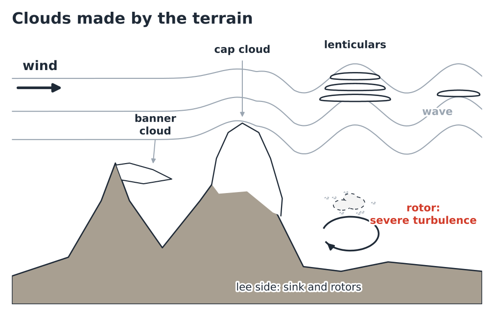
The cap cloud sits on a summit or a ridge. Seen from the lee side, it seems to pour down the slope like a waterfall that evaporates: this is the “foehn wall” when the flow is strong and lasting (chapter 6). It means that a significant wind is crossing the summit and that the air is moist at altitude. A saying common in the valleys has it that a mountain that “puts its hat on” is announcing bad weather: it is often true, because moisture and upper winds come ahead of frontal systems.
The banner cloud flies like a flag on the lee side of an isolated, pointed peak. Air drawn into the eddy that forms in the shelter of the summit rises there and condenses. It signals a strong wind on the summit.
Lenticulars (altocumulus lenticularis) are smooth lenses or saucers with sharp edges, sometimes stacked like plates. They form at the crests of a mountain wave: after crossing the terrain, the air oscillates up and down over tens of kilometres. They need a sustained wind, generally more than 30 to 40 km/h at ridge height and perpendicular to the terrain, and a stable layer aloft. They stay in place despite the strong wind: that is how you recognise them.
The rotor is an eddy with a horizontal axis, in the lee of the terrain, beneath the first wave crest. Sometimes marked by a ragged, boiling cloud, it is often invisible. On the ground beneath the rotor, the wind can blow the wrong way, towards the mountain.
In flight
Lenticulars above the massif: no flying, no debate, even if the wind is calm at launch. The calm at launch is sometimes that of a sheltered valley beneath a violent flow, with the rotor waiting above. A cap cloud or a banner cloud on the summits says the same thing on a smaller scale: the wind at altitude is already strong.
Hiker’s reflex
Under lenticulars, the arête and the pass will be windy, often gusty, with severe wind chill. A forest trail is still possible; a ridge route is not.
Sea of clouds and hill fog
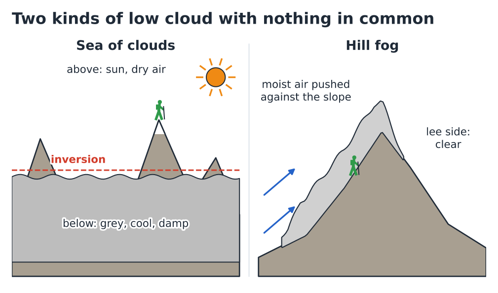
Two situations put summits in the grey or in the sunshine, for opposite reasons (Fig. P.10).
A sea of clouds is a sheet of stratus or stratocumulus trapped beneath an inversion, typical of autumn and winter anticyclones. Its top is as flat as a lake, often between 1,000 and 2,000 m. Above it, the air is dry, bright and often milder than below; beneath it, the day stays grey, cold and damp.
Hill fog forms when a moist airflow is pushed against a slope: the air rises, cools and condenses on the windward slope, often far lower than the day’s cumulus base. The opposite slope, in the lee, stays clear: it is the same mechanism as the foehn.
Pitfall
Launching above a sea of clouds means flying towards a landing field you cannot see. The sheet can also close up, during the flight, over the gap you were counting on to come down through. Without a clear field that you know, above the sheet, you don’t launch.
Hiker’s reflex
A grey morning in the valley under an anticyclone is not a bad-weather morning: climb up, the sun may be 500 m higher. Conversely, in hill fog, route-finding becomes difficult on broad ridges and plateaus: GPS track loaded, map in your pocket, and watch out for the windward slope, which stays in cloud all day.
P.8Reading a changing sky#
A single cloud is a photo; the weather is a film. What decides a day is the trend: is the sky improving, holding steady or deteriorating? Two scenarios come up again and again in the mountains.
The morning that turns stormy
The most frequent summer scenario in the Alps is the air-mass thunderstorm: no front, no frontal system on the chart, just warm, unstable air that the sun sets off (Fig. P.11). Around 09:00, small humilis appear over the best-exposed slopes. Around 11:00, they are well-formed mediocris. If, before midday, some grow clearly taller faster than they grow wider — towers, cauliflower tops, pileus —, what follows is often rapid: congestus, a top that smooths out, an anvil, the first rumbles early in the afternoon.
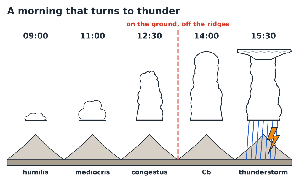
The pace varies with the air mass, but the rule is constant: it is the speed of development that counts, not the size. Cumulus that grow steadily all day without shooting up are reassuring; a single one shooting up before midday, and you need to rethink your plans.
The sky that veils over
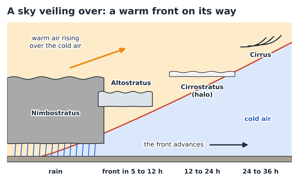
The other scenario is a frontal system arriving from the west (Fig. P.12). The first sign is often a fine sky streaked with cirrus, coming in from the west and multiplying. Then the sky turns white with a cirrostratus veil, and a halo. Then altostratus greys out the sun and erases the shadows. Finally nimbostratus sets in, with continuous rain. Between the first cirrus and the passage of the warm front at the surface, allow typically a day to a day and a half, sometimes less when the frontal system is fast-moving; the rain often starts a few hours before.
Hiker’s reflex
Cirrus invading from the west in the afternoon: the front is 24 to 36 hours away. A halo in the evening: tomorrow’s big outing may well end in the rain. Altostratus in the morning: plan the fallback route straight away.
P.9From cloud to decision#
Fig. P.13 and the table that follows sum up this prelude. The symbols do not replace the forecast: they show what each cloud adds to your decision when you see it with your own eyes, at launch or at the trailhead.
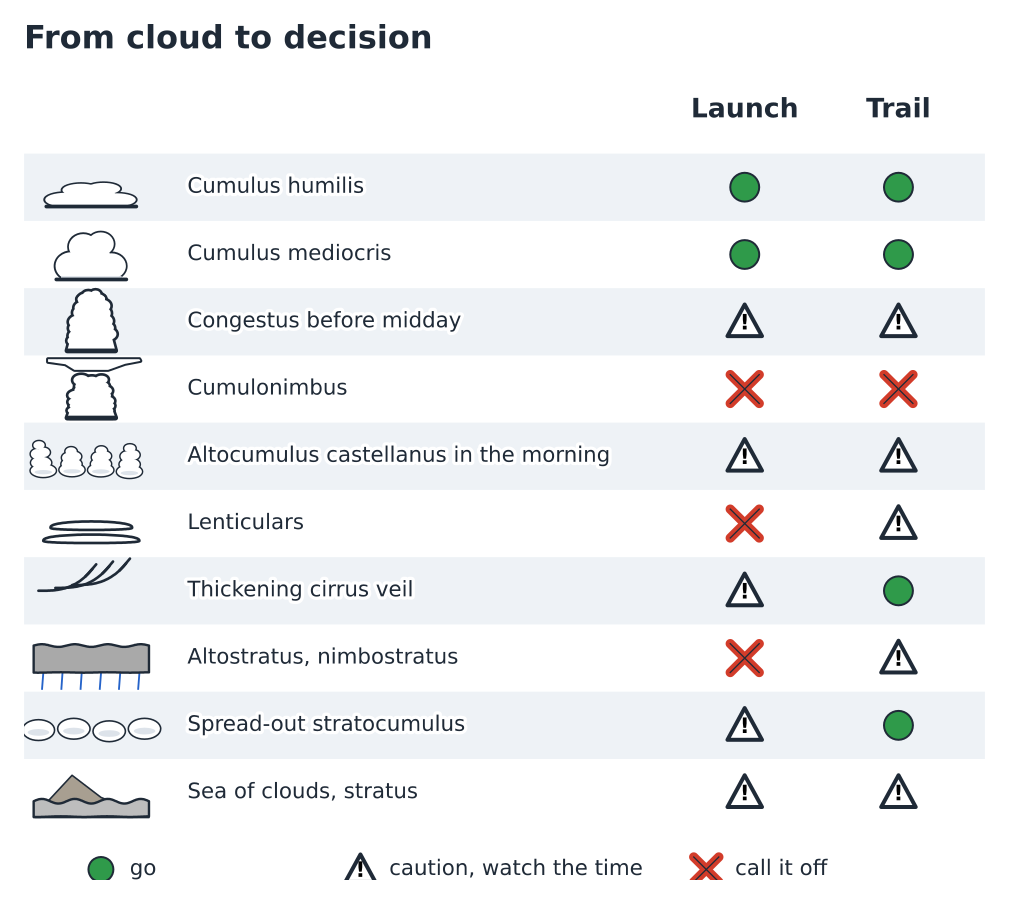
| What you see | At launch | On the trail |
|---|---|---|
| Cumulus humilis | Thermals often weak, low ceiling. | Nothing to fear. |
| Cumulus mediocris, well formed | Good day: aim for the clouds that are forming. | Fine weather; watch how it develops in the afternoon. |
| Congestus before midday | Fly early, land before 13:00–14:00, stay close to the landing fields. | Summit in the morning, off the ridges before midday. |
| Cumulonimbus, anvil, arcus | On the ground, well ahead of the gust front. | Come down off the ridges, keep away from high points. |
| Altocumulus castellanus or floccus in the morning | Thunderstorms likely: a short, early flight. | Very early start, turnaround time set. |
| Lenticulars, cap cloud, banner cloud | Strong wind at altitude, rotors: no flying. | Windy ridges and passes, low feels-like temperature. |
| Cirrus spreading in, halo | Thermals weakening earlier. | Window closing: front within 24 to 36 h, rain a few hours before. |
| Altostratus, nimbostratus | No thermals; rain close or already falling. | Short, sheltered fallback route. |
| Stratocumulus closing the sky | Day switching off: stay close to the landing fields. | Grey but no particular danger. |
| Sea of clouds, valley stratus | Landing field invisible: launch only above a clear field. | Sunshine possible higher up; route-finding inside the cloud sheet. |
P.10Exercises#
Your turn — the sky at 07:30
Late July, in the car park at a trailhead at 1,400 m, around 07:30. Blue sky over the valley; above the summits, a patch of altocumulus, several of whose elements carry small turrets. The forecast said “fine weather, a few isolated thunderstorms late in the day”. You had planned an 8-hour loop along a long arête, and your pilot friend a flight in late morning. What do you change?
Show the answer
The castellanus shows that instability is already present aloft: the thunderstorms are likely to come earlier, and to be more numerous, than “isolated late in the day”. For the hike: shorten the loop, or reverse it so as to cross the arête early, set a turnaround time around 11:00 and be off the ridge by midday. For the flight: launch as soon as the thermals allow, stay close to the landing fields, land as soon as the first congestus appear.
Your turn — calm at launch, lenses above
At launch, the windsock is almost hanging limp, and the weather is gloriously fine. Above the neighbouring massif, three smooth, stacked lenses have not moved for half an hour. A pilot tells you: “There’s no wind, let’s go.” What do you think?
Show the answer
Motionless lenticulars indicate a strong wind at altitude crossing the terrain, and an established mountain wave. The calm at launch may be that of a sheltered spot, or of a lull between two bursts of rotor. The risk is meeting a strong wind and violent turbulence a few hundred metres higher up, or on leaving the shelter. You don’t launch.
Your turn — which cumulus to aim for?
In flight at 13:00, you are looking for your next thermal. Ahead of you: 2 km away, a big white cumulus with slightly blurred edges and a grey, diffuse base; 3 km away, a small brand-new cumulus with hard outlines and a dark base. Which do you choose, and why?
Show the answer
The small one, further away. The big cloud has blurred edges and a diffuse base: it is at the end of its life and its thermal has probably stopped; you may even find sink there. The small cloud with sharp outlines is being born: it is fed by an active thermal. Under a newborn cumulus, look for the lift slightly upwind of the base.
Your turn — the evening halo
You are having dinner at the mountain hut. The weather has been gloriously fine, but since 17:00 the sky has been turning white from the west, and a halo now surrounds the moon. Tomorrow you are planning a 10-hour outing. How do you read this sky?
Show the answer
Cirrus then cirrostratus with a halo, coming from the west: this is the approach sequence of a warm front. The front may pass in 12 to 24 hours, and the rain often comes a few hours ahead of it: so it could start as early as tomorrow morning. Check the forecast, and consider setting off very early on a shorter objective, or postponing the big outing.
P.11Quick reference and glossary#
The prelude’s key figures
| Low level (mid-latitudes) | ground to 2 km |
| Middle level | 2–7 km |
| High level (ice) | 5–13 km |
| Tropopause in summer, top of Cb | ≈ 11–12 km |
| Lifespan of a fair-weather cumulus | ≈ 15–30 min |
| Spacing between two cloud streets | ≈ 2 to 3 × the depth of the convective layer |
| Cirrostratus halo | ≈ 22° radius |
| First cirrus → warm front passing at the surface | ≈ 24–36 h (rain a few hours before) |
| Congestus → cumulonimbus | sometimes less than an hour |
| Wind needed for lenticulars | > 30–40 km/h at the ridges |
| Top of a sea of clouds | often 1,000–2,000 m |
- Arcus
- Horizontal roll of cloud at the front of a cumulonimbus, beneath its base; marks the gust front.
- Castellanus
- Cloud species (mainly altocumulus) bearing turrets; a sign of instability aloft.
- Condensation level
- Altitude at which rising air reaches saturation; it is the flat base of cumulus (chapter 1).
- Congestus
- Cumulus clearly taller than it is wide, tower-shaped, with a cauliflower top.
- Anvil
- Spread-out, fibrous top of a cumulonimbus, made of ice, flattened beneath the tropopause.
- Fractus
- Ragged shred of cloud, often beneath a rain cloud or in a damp valley.
- Halo
- Ring of light of about 22° around the sun or moon, caused by the crystals of a cirrostratus.
- Lenticular
- Smooth lens-shaped cloud, stationary despite the wind, formed at the crests of a mountain wave.
- Mamma
- Rounded pouches hanging beneath an anvil or a cloud base; associated with turbulence.
- Sea of clouds
- Flat-topped sheet of low cloud, trapped beneath an inversion, with the summits rising out of it.
- Orographic
- Describes a cloud produced by terrain that forces the air to rise.
- Pileus
- Smooth cap above a building tower; a sign of very rapid lift.
- Rotor
- Eddy with a horizontal axis in the lee of terrain, beneath a mountain wave; strong turbulence.
- Cloud street
- Line of cumulus parallel to the wind, beneath which the lift is almost continuous.
- Virga
- Trails of precipitation that evaporate before reaching the ground; sink and gusts beneath.
What to remember
- Three keys are enough to name a cloud: the level (prefix), the shape (heaped = unstable, sheet = stable), rain (nimbo-, -nimbus).
- Ice clouds (cirro-) are not dangerous, but they give warning: cirrus spreading in, a halo, then altostratus = a frontal system is coming.
- Cumulus is the visible part of a thermal; its flat base marks the condensation level, and its shape measures the day’s energy.
- A congestus before midday, a castellanus in the morning: thunderstorms likely, so fly and walk early.
- Lenticulars, cap cloud, banner cloud: strong wind at altitude, waves and rotors; no flying.
- Sea of clouds and hill fog have nothing in common: one lies beneath an inversion, the other on a windward slope.
- What counts is not the cloud but how it changes: look at the sky every half-hour.
End of the prelude · Chapter 1 explains why air rises, why it condenses, and where it stops.